The re-population on Britain
Further History from Wikipedia

The re-population on Britain
Further History from Wikipedia
At the end of the last ice age, (circa 9000 BC) what are now the British Isles were joined to the European mainland as a mass of land extending north west from the modern-day northern coastline of France, Belgium and the Netherlands. Ice covered almost all of what is now Ireland and Great Britain with the exception of most of modern-day Munster and much of what we now call England.
Between 14,000 to 10,000 years ago, as the ice melted, sea levels rose separating Ireland from the mainland, creating also the Isle of Man.Between 2000 and 4000 years later, Great Britain became separated from the mainland. Britain probably became re-populated with people before the ice age ended and certainly before it became separated from the mainland. It is likely that Ireland became settled by sea after it had already become an island.
The first farmers to arrive in Britain.....
Ian Sample, science correspondent Tuesday 19 January 2010 wrote:-
Most British men are descended from ancient farmers. The first farmers to arrive in Britain outbred the native hunter-gatherer men and have left their mark in modern males' Y chromosome, farming in the blood: More than 60%
of British men have the Y chromosome that dates back to the origin of agriculture.
Most men in Britain are descended from the first farmers that migrated across Europe from the Near East 10,000 years ago, scientists say.
Ancient farmers left their genetic mark on modern males by breeding more successfully than indigenous hunter-gatherer men as they made their way west, a study has found.
As a result, more than 60% of British men, and nearly all of those in Ireland, can trace their Y chromosome back to the agricultural revolution, or more precisely the sexual success of the men behind it. These farmers' Y chromosome becomes more common in the West of England and reaches a national peak of 78% in Cornwall.
Men with surnames including Titchmarsh and Haythornthwaite are among the most likely to carry the farmers' Y chromosome, known as R1b1b2. The Y chromosome is passed down the male line only, from father to son.
"These farmers expanded into territories with small and sparse hunter-gather populations and moved on as time passed. The Y chromosome got caught up in that and it surfed the wave of expansion," said Mark Jobling, a geneticist at Leicester University and an author of the study.
The rise of farming is one of the most important cultural transformations in the history of modern humans. Increased food production allowed communities to settle rather than wander in search for food, a shift that heralded the huge expansion of the human population..
The first European farmers came from the "fertile crescent" that stretched from the eastern Mediterranean to the Persian Gulf, but experts have argued whether the westerly spread of agriculture was driven by the cultural transmission of ideas and technology, or by migrating farmers.
Researchers led by Jobling collected DNA samples from more than 2,500 men across Europe. Around 80% of the men had the R1b1b2 type of Y chromosome, making it the most common lineage on the continent.
A map showing the distribution of the chromosome across Britain reveals that it became increasingly common but less genetically diverse from the south east to the north west. The analysis, published in the journal PLoS Biology, suggests the R1b1b2 Y chromosome entered the country with the earliest farmers in the south east and gradually spread west as they migrated.
Genetic tests on women showed that most are descendants of hunter-gatherer females. "To us, this suggests a reproductive advantage for farming males over indigenous hunter-gatherer males during the switch from hunting and gathering to farming," said Patricia Balaresque, a co-author of the study,
"Maybe back then, it was just sexier to be a farmer."
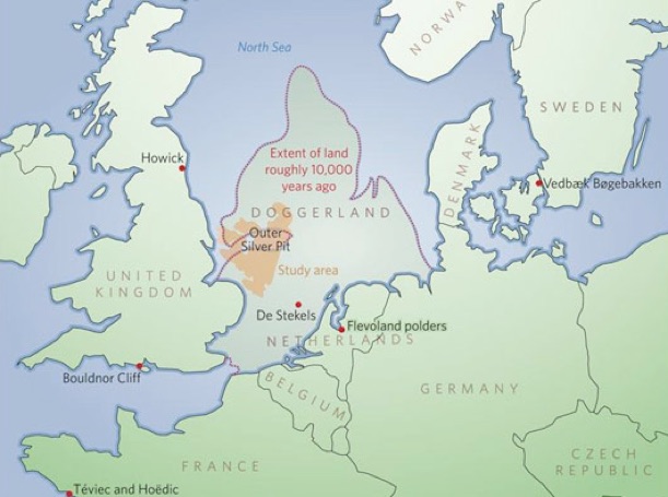
Doggerland From Wikipedia.......
Celtic Britain and The Roman Invasion.....
At the time of the Roman Empire, about two thousand years ago, various tribes were inhabiting the islands. The Romans first invaded Britain in 55 BC and later returned with the intent of expanded their civilisation to first control southern Great Britain moving steadily west and northwards but were impeded in advancing any further, building Hadrian's Wall to mark the northern frontier of their empire in 122 AD. At that time, Ireland was populated by a people known as Scots, the northern part of Great Britain and Scotland by a people known as Picts , Celts in Wales and the midlands and southern half by Britons.
Britannia was valuable and the Roman emperors knew it and guarded it against raiders such as the Irish, Picts, Scots, Angles and Saxons.
The Gododdin tribe lived in the west borders region with the land now known as lowland Scotland and the Selgovae in the east. This area, between Hadrian’s Wall and the Antonine Wall was called Valehtia by the Roman administration. At the end of the 4th century Valehtia was considered an extension of the Empire. This meant the local tribes, the Gododdin, Strathclyde and Rheged became Roman citizens.
The Picts who lived north of the Antonine Wall, outside of the Empire had been the curse of Britannia for generations. Roman forces struggled to contain them, despite stationing more troops in Britannia than any other Roman province. In 342, trouble was severe as the Picts mounted heavy raids throughout the old territory of the Selgovae, burning the Roman outpost forts of High Rochester, Bewcastle and Risingham. As a result in 343 the Roman administration entrusted the Gododdin tribe with the task of containing the Picts, establishing a military regiment known as the ‘Areani’, the situation however continued to worsen.
In 367 a remarkable event took place. In what the Romans called ‘The Barbarian Conspiracy’, the Picts from the north, the Scots from the west and the Franks and Saxons from Europe attacked Britannia and Gaul simultaneously. It seemed as if the ‘Areani’ had been bribed not to report the build-up of forces. Leading these raids was the Atecotti tribe. In old P-Celtic this means ‘The old peoples’, who came from Caithness, Sutherland and the north and western Isles. They spoke not P or Q-Celtic and may have used Ogham script to write. Apart from some names, the rest of their texts are unintelligible to us.
‘The Barbarian Conspiracy’ came to a head in 368 and in 395, because of their treachery, a man known as Theodosius was sent to Britannia and abolished the ‘Areani’. He decided not to re-occupy the outpost forts north of Hadrian’s wall.
He re-organised Roman army in Britain into three sections, each under the control of a different officer.
The first and most senior was the Dux Britanniarum which meant ‘The Commander of the British’. Organised into 14 units, all but 3 were stationed east of the Pennines in Durham and Yorkshire. Three units were a new type of cavalry regiment that operated independent of infantry.
The second section under the command of the Dux ‘Leader and Commander’, was the entire garrison of Hadrian’s Wall. A record known as the ‘Notitia Dignitatum’ written in 375 AD lists each fort and its occupants, including the ‘Prima Cohort Conoviiorum’ made entirely of British Cornovii axillary troops. This Cohort was stationed at the fort of ‘Pontus Aleas’ that guarded the first and most important bridge over the river Tyne at what is now Newcastle.
The third section in the south of Britain was the ‘Comitatenses of Britain’ under the leadership of the Count Litorus Saxonica which meant the Count of the Saxon shores.
Shortly after 367 AD, Hadrian’s Wall was strengthened and re-garrisoned having been largely abandoned due to overwhelming attacks. Theodosius took three of the four original tribal groupings, which had grown into the kingdoms of Strathclyde, Gododdin and Rheged and set professional soldiers in charge of their mostly independent cavalry troops.
Before the Roman invasion of Britain in 55 BC, many different Celtic tribes populated all parts of Britain. This was the Iron Age and Britain had been divided and ruled for years by Celtic tribal chiefs, most of whom maintained defended enclosures on the tops of prominent hills known as hill forts. Most were status symbols, not easily defended and designed to impress and establish ownership and command of tribal lands. These British Celts were purer than their continental cousins, having been cut off on the islands of Britain for several thousand years since the end of the last Ice-Age when sea levels rose forming the British Isles. Living in what we now call Britain they spoke an early form of Welsh known as P-Celtic. Other Celtic tribes in the regions now known as Scotland, Ireland and mainland Europe spoke a different dialect known as Q-Celtic. In Scotland, north of what we now call the borders, and above a line from Glasgow across to Edinburgh, there was another tribe called the Picts who spoke an even earlier Celtic dialect of which little is known as it was never written down. The Picts were so called by the Romans as they painted designs on their bodies. (Latin. Picturatus - painted)
By 100 AD most of Britain’s Celtic tribes had been de-militarised by the Roman administration and were no longer living in defended hill-top villages. These ‘civilised’ Celts became known as ‘Romano British’ and were mainly farming the land for a living, selling their surplus produce in newly created market towns or directly to the Roman administration, Some were Artisans or craftsmen, who lived in villages surrounding these market towns.
A fine network of Roman cobbled roads connected all parts of central Britain. Only the far southwest peninsular (Devon and Cornwall) and the Welsh uplands were left alone to their pre-Roman Celtic ways.
The Roman army, supported by Continental or Middle Eastern auxiliary troops maintained order and protected the economy that was flourishing on the island of Britannia. On the whole, Britannia was at peace. The growing market economy meant wealth and the ability to pay the taxes levied by the Roman administration, that also paid for the occupying army.
On what are now the Welsh borders (Clwyd, Powys, all of Shropshire, most of Cheshire and parts of Staffordshire) lived a tribe known as the Cornovii. To the east were the Catuvellavni and to the south the Dobunni. Most Cornovii land was hilly and at that time the terrain was covered by light scrub that was easily cleared. For these reasons it was widely settled from the Stone Age and again when the ice receded at the end of the Ice Age about 10,000 years ago.
The first mention of the Cornovii people occurs in the writings of the Roman, Claudius Ptolemaells (or Ptolemy) in the 2nd Century AD. The Cornovii had many hill forts, one of the largest being ‘The Wrekin’ in Shropshire. This overlooked the site of their later Romano-British tribal capital Viroconium Corniovorum (Wroxeter). The town of Mediolanum (now Whitchurch in Shropshire) became another Cornovii Romano-British settlement and its street plan suggests a small walled town.
Cornovii lead and silver mines on Shelve Hill in Shropshire were likely to have been controlled from the nearby Roman fort of ‘Levobrinta’ at Forden Gaer, Powys. (www.roman-britain.org/places/levobrinta.htm). Later possibly as a civil concern they were perhaps administrated from the nearby villa at Linley, near the village of More.
For further information see the book ‘The Cornovii’ by Graham Webster. www.roman-britain.org/places/viroconium.htm
The Cornovii were defeated by the Romans in 46 AD, at a decisive battle at their Wrekin hill fort. This appears to be the only fight that the Cornovii put up. However, after that defeat, the Cornovii quickly settled down and readily adopted the Roman way of life under the watchful eye of the 10th legion. They adopted an urban style of living in a new town of Viroconium Corniovorum (Wroxeter) developed from the Roman fort originally built to subdue the Cornovii.,
In 200 AD when the Xth Legion were transferred from Viroconium Corniovorum (Wroxeter) to establish another fort that later developed into the town of Deva (Chester), the Cornovii took over the protection of the Viroconium Corniovorum which was destined to become the fourth largest city in Roman Britain after Londinium (London), Camulodunum (Colchester), and Verulamium (St Albans).
When the Xth. Legion left, The Cornovii were distinguished as the only British tribe ever awarded the position of a Civitas. This allowed the tribe to manufacture and carry arms to defend the city.
There are records of Cornovii auxiliary soldiers and their involvement in campaigns in the Roman record known as the ‘Notitia Dignitatum’. There is one great indicator that the Cornovii were considered as a great warrior tribe - the fact that they were also the only Civitas to have a Roman Legion named after them, The ‘Cohors Primae Corniovorum’ were stationed in the 3rd century at the fort of Pontus Alias on Hadrian’s Wall, at a site north of the river Tyne (Newcastle upon Tyne). Pontus Alias guarded the first crossing point on the river from the estuary.
What happened to the ‘Cohors Primae Corniovorum’ after Britain was left to administrate and defend itself? No one really knows. Did they go with Constantine III to their deaths in Gaul? Did they remain as paid mercenary troops defending the north from continuing attacks by the Scot and Pictish border Revers (Raiders) that had been the bane of Roman Britain for so long?
Did some return to their tribal region on the borders of Wales and help form the backbone of what was to become the Powysian Kingdom? Did some, (as accepted, but not proven by Professor John Morris), migrate to the southwest peninsular of Britain and defend the local tribes and rich tin mining industry against invasion by the Irish? and as the ‘Morris theory maintains that they eventually give their name to the region know known as Cornwall (Cornovii of the Wall)?
The end of Roman rule.....
After the end of Roman rule in Britain (circa 410 AD) Viroconium Corniovorum, the civitas of the Cornovii tribe (now Wroxeter) witnessed a substantial re-building programme in timber rather than stone, with a covered market place for local Romano-British craftsman. After this period of stability, owing to the relentless expansion of Anglian power in the British midlands, the Cornovii tribe fell under the rule of the Kingdom of Pengwern and was later consumed by the neighboring Anglo Saxon Mercia after 642 AD.
The indigenous Cornovii people may have continued to reside in the area, perhaps referred to as ‘Wrekensaete’, under Mercian rule. Wrekensaete approximates in P-Celtic to ‘Wrekin-dwellers’, keeping their city of Viroconium (Wroxeter) going until the early 6th Century, a full two hundred years after Roman influence left Britain.
The history of Wales and Britain, in the wake of the Romans is beset by a monumental lack of plausible written documentation. In other words, it is incredibly hard to say for certain what happened in the so called ‘Dark Age”. With that disclaimer established, the kingdom of Powys incorporated the lands of the Cornovii tribe and those of the royal family of Gwryheyrnon, while the former lands of the Silures became the foundation of the Kingdom of Gwent.
One of the British leaders following the departure of the Romans, was Vortigern (Gwyrtheryn of Welsh legend), who may have been a native of the Welsh borders. The kings of Powys claimed him as an ancestor. It was Vortigern who is blamed for inviting Romano-Saxon soldiers as mercenaries into Britain to help maintain order in parts of Britain in the period immediately following the departure of Roman troops in 410 AD. When the money to pay these mercenaries ran out, they began to exert their position, rebel and gradually take control of large sections of Britain from the indigenous Celtic British. They started on the east coast and worked up, down and across the island of Britain.
One of the leaders of British resistance to these Germanic tribes (which we now call Saxon, Angles or English), was Ambrosius (Emrys Wledig of Welsh legend). Ambrosius is likely to have come from the Romano-British aristocracy bringing Roman military training and experience. There is some suggestion that he was a rival of Vortigern.
Ambrosius is closely associated with the legends of Arthur. Some scholars have argued that he is Arthur, others that Arthur was a war leader for Ambrosius. Ambrosius, Arthur or a similar Romano-British leader (or amalgam of leaders) did marshal a British force assembled from troops assigned by a number of tribal leaders. They waged war against the Irish and Pictish raiders and halt the territorial expansion of the Anglo-Saxons from the South East, East coast and North East coast.
Some time around 496 AD, the advance of the Saxons was halted, perhaps following a decisive battle at a place called ‘Mons Badonicus’ (Mount Badon), possibly close to the city of Bath. Although the specific details of the battle are not known and even its reality is questionable, archaeological evidence has shown that the Saxons were subdued and pushed back for some fifty years, with some even leaving Britain to settle on the continent again.
There is evidence that a man called Owen Thanquin ruled at Viroconium Corniovorum (Wroxeter) at the beginning of the 6th century. He was a warlord who is credited with the re-building and fortification of what had been the fourth largest Roman city in Britain. In common with other warlords, Owen Thanquin took the name of an animal. In his case The Bear. In the P-Celtic language, the word for a bear was Arth.
Owen Thanguin was reputedly buried at Bath church. A 10th century poem relates that it was built on the site of an ancient fortified settlement of about one acre. The church of Bassa is where one of Arthur’s sites is said to be.
The fact that the Cornovii were the only indigenous Celtic tribe in Britain to serve in the Roman army within their own country, is significant. Normally the Roman authorities deployed auxiliary troops recruited in foreign lands to serve in other foreign lands, hence the Romano-Saxon axillary troops guarding the north of Britannia and elsewhere.
The Cohors Prima Cornoviorum were stationed at the fort of Pons Aelius at the eastern end of the wall from the mid 3rd century until 410 AD when the Roman legions were withdrawn from Britain. The auxiliary troops were disbanded and taken with the legions to other parts of the empire or at least ceased to be paid by Rome.
No one is sure what type of auxiliary unit the Cohors Prima Cornoviorum originally were, light cavalry, infantry, or other type. A Cohort consisted of around 500 men and was often a specialist fighting unit or special force. They must have been highly regarded to have been called Prima and the only indigenous troops to be deployed in Britain. By 410 AD most troops on the northern frontier had become mounted cavalry, that being the most efficient and flexible way to cover the wide open spaces of Valehtia, between Hadrian’s wall and the abandoned Antonine wall built between what is now Glasgow and Edinburgh. It followed the firth of Forth from the east and connected with the river Clyde in the west.
One thing is sure; the north of Britain continued to be raided by the Irish and the Picts long after Roman rule ceased. The tribes in prosperous central and southern Britain had been de-militarised for so long that they had to employ foreign mercenaries such as ex Romano-Angle and Romano-Saxon auxiliaries, who had also been part of the Roman army in Britain and on the continent of Europe. Unfortunately this was going to rebound on them as the British chiefs ran short of money to pay them and their numbers grew to a level that enabled them to take control. This was the so-called Anglo-Saxon invasion, or rather, take-over.
The frontier region of Valehtia in northern Britain was not so civilized. The Celts from Wales and certainly the Cornovii were of one race speaking the common language of P-Celtic, sometimes referred to as ‘Old Welsh’. The region was wild and relatively unprosperous, with little employment compared to other parts of Britannia. The indigenous people were still militarised, some being trained by the Romans and were familiar with Roman discipline and military tactics.
Constant raiding from Ireland in the west and Scotland in the north resulted in the area of Britain between Hadrian’s Wall and the Antonine wall (had led to the region being established by the Prefect Quintitius Clemens as ‘Valehtia’) being strategic in the defense of mainland Britannia.
The Romans established treaties with the indigenous Valehiia tribe, Damnonii tribe, as well as the Selgovai tribe in the east and the Gododdin tribe in the west, but had never fully subdued them. Certainly the Pictish tribes were never brought to heal and continued to raid, steal and pillage down as far as Chester and even London at times.
The Selgovai and the Gododdin were British and spoke P-Celtic not Q-Celtic as the Irish, Scottish, Angles and Saxons did.
P-Celtic, an early form of Welsh set them apart from the Scottish tribes. They were in fact kinsmen or Cumrie of all Britain and probably had no problem joining forces with their brother P-Celts against the growing number of threatening interlopers.
Certainly the first and oldest threat was from the border raiders (Reavers) and the Irish who were an established threat well before the Romans, Angles, or Saxons. This meant that Valehtia in the north of Britain was most probably the first battleground for the new Celtic confederation.
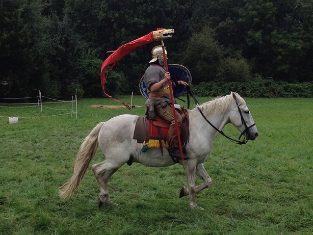
Alistair Moffatt’s book ‘Arthur and the lost Kingdoms’ explores the possibility that the Arthurian legends were first established in the far northern territory of Valehtia. Skilled independent Romano-British cavalry was a development of the Sarmatian cavalry introduced to Britain by the Romans. They were just what was needed to turn the tide against less disciplined Q-Celtic speaking warriors who fought largely on foot, perhaps with a few chariots. Especially interesting is that the Sarmatian cavalry horses may have been considerably more intimidating, being substantially larger or at least more powerful that the native British ponies. They may also have had substantially grater endurance.
The Sarmatians.....
Up to the 5th century, Sarmatians cavalry units were stationed in Britain as part of the Roman army. Before long the Romans began to copy the Sarmatian style of lance cavalry and by Hadrian’s reign (117 to 138 AD) one of the main varieties of Roman horsemen were those who carry the ‘contus’ lance attacked in the manner of the Sarmatians.
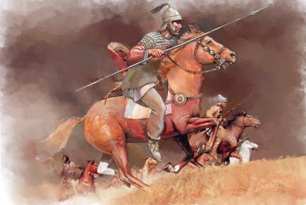
Other innovations, thought to have been adopted by the Romans from the Sarmatians include the ‘Draco’ (or screaming dragon) standard and perhaps the spangenhelm which was a strap on combat helmet. It is quite possible that the ‘horned’ saddle was also influenced by Sarmatian tradition.
According to Littleton and Thomas (1978), the legend of King Arthur, the prototypical knight of high medieval literature, was directly inspired by the presence of Sarmatian type cavalry in Britain.
By making good use of the still existing Roman road network, decaying Roman forts and re-occupied hill forts, this well- organised and efficiently led confederation, stood a good chance of turning the tide, as the limited dark-age accounts seem to suggest.
Alistair Moffatt pieces together a strong case that the area known as Valehtia was the starting point of the only successful campaign to be mounted in Britain against these raiding or occupying interlopers.
By translating P and Q Celtic place names and throwing new light on some significant but rare accounts written some years later by Bede, Gildas and Geoffrey of Monmouth, Moffat hypothesises that Arthur, or at least the Arthurian legend may have originated in the Tweed valley and the borders region of Valehtia. Roxborough castle, still evident by the later city of Kelso, mat well have been pivotal in this.
Following the adoption of Sarmatian cavalry by the Roman army, capable of operating on their own, an entirely new strategy developed in this frontier country, Cavalry horses had to be bred, trained, fed and protected and the Romans established new types of forts especially for their new cavalry.
The confederation built on this strategy and it is likely that the site of Roxborough castle by Kelso was their main base. Strategically positioned near the north/south Roman road called Dere Street, built by the Romans to connect York to the northern frontier, Roxborough preceded Kelso as a well defended base. Its unique position on an easily defended piece of land between the rivers Tweed and Teviot, that merged at the junction pool, was the perfect spot. The castle mound at one end commanded views over many miles in each direction and overlooked the 200 yards of flat ground beneath this provided protected access to the land that offered space for secure housing, farming and grazing for horses.
Moffatt also suggests that, of the twelve battles recounted in the Arthurian legends, most could well have been fought in these border regions. He recounts that the unique use of cavalry against warriors who mainly fought on foot, is assisted by choosing the right ground on which to fight. Rivers and river crossings offer many advantages to fast moving, well-trained cavalry. By looking for such places, and unraveling P and Q Celtic place names and written accounts, Moffatt’s book ‘Arthur and the lost Kingdom’: has pinpointed several likely locations, of the twelve battles.
I note from Alistair Moffat’s book
“The first battle was said to have been at the mouth of a river, known as Glen. A river of this name is in Northumberland and runs into the river Till, which runs into the river Tweed. Firmly at that time in the territory of the Goodwin nearby their stronghold fortress of Yeavering Bell, only 15 miles from Bamburgh to the east and a few miles from Roxbrough to the west. I have visited the spot and it is only one day’s ride from Roxbrough, the hill fort of Yeavering Bell offered safe overnight accommodation with protected grazing for the horses.”
“The second, forth and fifth battles were beyond another river called Dubglas (Douglas), in the region of Linnuis. Dubglas is P-Celtic for ‘Dark River’. Moffat tells us that there is a river Douglas that flows into the River Clyde near Lanark, and even a village named Douglas and a castle Douglas guarding the only safe route from the north. It may be here, in the area between the Firth of Forth and the river Clyde, where Arthur halted the Pict and Scot raiders in this brilliant campaign.
“The sixth battle was beyond the river known as Bassus. Little evidence exists to locate a river of this name at that time in northern or even middle Britain.”
“The seventh battle was in the woods of Celidon, pronounced ‘Cat Coit Celidon’. Most likely in the Ettrick Forrest to the west of Selkirk in the heartland of the Selgovae tribe in the border region of Valehtia. Moffat questions the identity of the enemy who fought against Arthur in this battle. Rather than the Angles, he suggests that it must have been the Picts. He recounts a rare piece of Dark Age archaeology, which definitely locates the site of a battle of around 500, at Yarrow Kirk. Eight miles west of Selkirk, hard by the river of the same name, there is a stone bearing a remarkable description. Very weathered now and difficult to read, the Yarrow stone carries these words:
Hic memoria perpetua
In loco insignisimi principes Nudi Dumnogeni.
Hic iacent in tumulo duo filii Liberalis.
Which translates as:
This is the everlasting memorial
In this place lie the most famous princes Nudus and Dumnogenus.
In this tomb lie two sons of Liberalis.
Taken from RCAHMS, Selkirkshire (1957)
The area around the Yarrow Stone also remembers an ancient battle and to the south-west by a crook in the river, there is a marshy area long known as the ‘Dead Lake’. Tradition holds that was a mass grave for the rank and file warriors killed in the same action that claimed Nudus and Dumnogenus. In 1803 the local landowner decided to exploit the land and removed several barrows, under which were found hundreds of bones that disintegrated into white dust when exposed to the air. The local priest, a keen gardener, used the white dust to fertilise his garden by the church.
Near by, on the ridge overlooking the battlefield is an old cottage named ‘Warriors’ Rest’, with another stone marker.
At Yarrow Kirk one can see the Yarrow stone, along with other stone markers and ‘Warriors Rest’ cottage in a line on the hill overlooking the river. The terrain suits cavalry against foot soldiers. There is a flat flood plain that is mostly well drained, close to a river crossing, which is no longer used now. However, Arthur’s opponents were Picts who also had cavalry, albeit on ponies and some chariots, his victory may have been hard fought, this may have claimed the lives of two P-Celtic princes, who sound like Damnonians from Strathclyde along with other warriors buried in a place that people remembered.
Arthur’s battle of Celidon wood is the only battle in the Nennius that no one disputes. Just as in the epic poem ‘The Gododdin’, written in Edinburgh by Aneirin (ca. 600), Arthur has his earliest literary reference and put in his right place: as a leader of battles, a cavalry general who led the coalition army of the P-Celtic kingdoms of the Old North, the Cymry.”
“The eighth battle was at the stronghold of Guinnion, in which Arthur carried a likeness of Holy Mary everlasting Virgin on his shield, and the heathens were turned in flight on that day and there was a great slaughter upon them because of the goodness of our Lord Jesus Christ and the goodness of the Holy Virgin Mary his mother.”
“The ninth battle took place in the City of the Legion. Possibly York, the old headquarters of army command - north and where the Sixth Legion had been based for 200 years. Another possibility is Chester, where the Roman Amphitheater had been converted into a defensive stronghold, as had others on mainland Europe.”
“The tenth battle took place on the banks of a river, which is called Tribruite.”
“The eleventh battle was fought on a hill known as Agned, or in another version of the Nennius text, Agned is replaced by Bregion, which is P-Celtic for Bremenium (an important outpost fort on Dere street, north of Hadrian’s Wall, near the hamlet of Rochester on the A68 north of Otterburn). Impressive walls remain from the fort of Bremenium in what is now called High Rochester, a mile or so up a lane from the hamlet.”
One can visit the remains of the fort and walk the walls surrounding the area of the fort, now the village green and within the walls are several later dwellings that are still lived in by folk who enjoy a quiet yet beautiful place to live. Dere Street passed close by the east gate of the fort. There is an interesting walk down to the banks of the River Rede in the valley below. Arthur and his Gorgons could have remained hidden whilst waiting, in the protection of the old fort, for a Saxon raiding force to travel north up Dere street from their base at York.
“The twelfth battle was at Baden Hill in which Arthur destroyed 960 men in a single charge on one day, and no one rode down as many as he did by himself.”
The most popular place to locate the Battle of Badon Hill is a mile or so north of Bath. Nennius, writing in the 800s, seems to say in his Historia Brittonum that Bath and Badon are the same place. The Romans called the city ‘Aquae Sulis’ (the waters of Sul) but it is possible that the post-Romans knew it as Badon.
The word ‘the’ in early British was indicated by the syllable ‘dd’, just as today Gwynedd is pronounced Gwyneth, so Badon may have been pronounced Bathon. It is difficult to know whether this sort of logic points to the truth, or is simply clutching at straws. The Anglo-Saxon Chronicle mentions the capture of Bath in 577, under the name Baoanceaster. The city did lie in a desirable strategic position and would have been a likely target of the Saxons. The place held religious significance for the British as well. The battle is referred to as that of Badon Hill and it has been suggested that Mount Badon is one of the hills on the outskirts of Bath, with Little Solsbury Hill as the most popular suggestion.”
“And in all these battles Arthur emerged the victor”. (Nennius, Historia Britonium, in John Norris
The suggested battle sites as well as Roxborough castle can be visited. At the castle one can walk the perimeter of the protected grazing area for the cavalry horses, brood mares, and foals. Alistair Moffat could well be on to something as the Cornovii military connection (with both this area in the north, the Welsh border country and the southwest peninsular of Devon and Cornwall) all seems to fall into place.
Historians and enthusiasts will have to make up their own minds; few records exist from the so-called ‘dark ages’ or are likely to be found. However our understanding and insight into these times is getting better and better. Alistair Moffat’s book, ‘Arthur and the lost kingdoms’ and other books well-written and researched on the subject, offer fascinating insights and stimulate thought as to what happened in those times and how they may have potentially included some of the Cornovii tribe Romano Roman trained soldiers and connected with the Pendred family’s past.
For more: -
‘Arthur and the lost Kingdom’by Alistair Moffatt Click here
‘The Legend of Caractacus’ by Alex Byles. Click here
‘On the Trail of King Arthur in Shropshire’
After Baden, the British had a period of about fifty years of peace. Many of the Saxons returned to the continent or at least stayed in the east and southeast of Britain.
Even though the Briton’s had the upper hand, they seem to have made no attempt to assimilate their halted opponents. This, in the Dark Ages, would have meant primarily a Christian mission. The British Church failed to launch one. It did evangelise the Picts and the Scots but left their third enemy, the Anglo Saxons alone.
Britons, in general, were willing to let the Teutonic pagans go to perdition. Pope Gregory sent St. Augustine from Rome to Kent to convert the Angles and the Saxons. He invited the Welsh clergy to join him in the mission and they refused. From then on they were isolated from Rome.
During the 540s Gildas’s ‘Complaining Book’ wrote his ‘Liber Querulus de Excidio ct conquest Britanniae’. The book does reveal a considerable survival of Roman learning, but the mind that harbors it is old fashioned and backward looking, with an aroma of being out of date. Gildas declares that Mount Badon put an end to foreign but not civil wars. For a while, evidently, these wars were mainly local affrays, and the Britons on the whole flourished.
Gildas’s post-Badonic phase of prosperity and order supplies the basis for the legend of Arthur’s reign. However, when a generation grew up that had not been involved in the struggle, they took the peace for granted,
Britain’s moral and political cohesion began to dissolve. Rulers ignored the danger from outside and the social order succumbed to feuds, fragmentation and irresponsibility. The battle of Camlann may have been the first serious breach, though Gildas does not mention it. He does murkily disclose the first step in a well-recognisable process. Arthur’s Britain, unable to maintain a united front, broke up into three regions (sub-Britain) none of which saved more than a fraction of the full heritage.
Very gradually the term ‘British’ became less apt to the Celtic people than the term ‘Cymry’ meaning ‘fellow countrymen’ An ethnic bond, instead of a claim to the island of Britain. The Anglo Saxon word ‘Welsh’ meant foreigners.
A sort of Northern Wales stretched from the Pennines into Scotland, with its terminus just beyond Dunbarton. Whilst
the peninsula from Somerset to Lands End with its scattered islands was known as West Wales. Within these areas there were further divisions.
In the 540’s, when Gildas writes, a much longer extent of Britain exists.
Add info on not maintaining the breed of cavalry horses and battle trained soldiers. By 550 the Anglo-Saxons were on the move again and with no cohesive force of British eventually took control of Britain.
Anglo-Saxon Britain.
The Romans brought Anglo-Saxons auxiliary troops in the Roman army to serve in Britain. After the Roman army withdrew from Britain in circa 410 AD many of these auxiliary troops staid on to protect local Romano-British chieftains from attack mainly from the Picts and Scotts. As Roman power waned in the 5th century AD more arrived from Germany. Initially, their arrival seems to have been at the invitation of the Britons as more mercenaries to repulse incursions by the Scots and Picts. In time, Anglo-Saxon demands on the British became so great that they came to culturally dominate the bulk of southern Great Britain, though recent genetic evidence suggests Britons still formed the bulk of the population. This dominance creating what is now England and leaving culturally British enclaves only in the north of what is now England, in Cornwall and what is now known as Wales. Ireland had been unaffected by the Romans except, significantly, having been Christianised, traditionally by the Romano-Brition, Saint Patrick. As Europe, including Britain descended turmoil following in the collapse of Roman civilisation, an era known as the Dark Ages, Ireland entering a golden age and responded with missions, first to Great Britain and then to the continent, founding monasteries and universities and were later joined by Anglo-Saxon missions of the same nature.
Dark age Britain lasted from 410 AD to the 9th century. During this time Celtic British rule was continually threatened by the relentless westerly movement of Anglo-Saxon control. This was the ‘Age of Arthur’ and many myths and legends have been handed down. Certainly the westerly advance of the Angles and the Saxons was halted for some years but eventually Celtic Britain secumed and although still British the native people became indistinguishable from Anglo-Saxons .
The Viking invasion.
Viking invasions began in the 9th century, followed by more permanent settlements, particularly along the east coast of Ireland, the west coast of modern-day Scotland and the Isle of Man. Though the Vikings were eventually neutralised in Ireland, their influence remained in the cities of Dublin, Cork, Limerick, Waterford and Wexford. Anglo-Saxon England however was slowly conquered around the turn of the first millennium AD, and eventually became a feudal possession of Denmark.
The Norman Invasion.
The relations between the descendants of Vikings in England and counterparts in Normandy, in northern France, lay at the heart of a series of events that led to the Norman conquest of England in 1066. The remnants of the Duchy of Normandy, which conquered England, remain associated to the English Crown as the Channel Islands to this day. A century later the marriage of the future Henry II of England to Eleanor of Aquitaine created the Angevin Empire, partially under the French Crown. At the invitation of a provincial king and under the authority of Pope Adrian IV (the only Englishman to be elected pope), the Angevins invaded Ireland in 1169. Though initially intended to be kept as an independent kingdom, the failure of the Irish High King to ensure the terms of the Treaty of Windsor led Henry II, as King of England, to rule as effective monarch under the title of Lord of Ireland. This title was granted to his younger son but when Henry's heir unexpectedly died the title of King of England and Lord of Ireland became entwined in one person.
By the Late Middle Ages, Great Britain was separated into the Kingdoms of England and Scotland. Power in Ireland fluxed between Gaelic kingdoms, Hiberno-Norman lords and the English-dominated Lordship of Ireland. A similar situation existed in the Principality of Wales, which was slowly being annexed into the Kingdom of England by a series of laws. During the course of the 15th century, the Crown of England would assert a claim to the Crown of France, thereby also releasing the King of England as from being vassal of the King of France. In 1534, King Henry VIII, at first having been a strong defender of Roman Catholicism in the face of the Reformation, separated from the Roman Church after failing to secure a divorce from the Pope. His response was to place the King of England as "the only Supreme Head in Earth of the Church of England", thereby removing the authority of the Pope from the affairs of the English Church. Ireland, which had been held by the King of England as Lord of Ireland, but which strictly speaking had been a feudal possession of the Pope since the Norman invasion invasion was declared a separate kingdom in personal union with England.
Scotland, meanwhile had remained an independent Kingdom. In 1603, that changed when the King of Scotland inherited the Crown of England, and consequently the Crown of Ireland also. The subsequent 17th century was one of political upheaval, religious division and war. English colonialism in Ireland of the 16th century was extended by large-scale Scottish and English colonies in Ulster. Religious division heightened and the King in England came into conflict with parliament. A prime issue was, inter alia, over his policy of tolerance towards Catholicism. The resulting English Civil War or War of the Three Kingdoms led to a revolutionary republic in England. Ireland, largely Catholic was mainly loyal to the king. Following defeat to the parliaments army, large scale land distributions from loyalist Irish nobility to English commoners in the service of the parliamentary army created the beginnings a new Ascendancy class which over the next hundred years would obliterated the English (Hiberno-Norman) and Gaelic Irish nobility in Ireland. The new class was Protestant and British the common people were, largely Catholic and Irish. This theme would influence Irish politics for centuries to come. When the monarchy was restored in England, the king found it politically impossible to restore all the lands of former land-owners in Ireland. The "Glorious Revolution" of 1688 repeated similar themes: a Catholic king pushing for religious tolerance in opposition to a Protestant parliament in England. The king's army was defeated at the Battle of the Boyne and at the militarily crucial Battle of Aughrim in Ireland. Resistance held out, and a guarantee of religious tolerance was a cornerstone of the Treaty of Limerick. However, in the evolving political climate, the terms of Limerick were superseded, a new monarchy was installed, and the new Irish parliament was packed with the new elite which legislated increasing intolerant Penal Laws, which discommoded both Dissenters and Catholics.
The Kingdoms of England and Scotland were unified in 1707 creating the Kingdom of Great Britain. Following an attempted republican revolution in Ireland in 1798, the Kingdoms of Ireland and Great Britain were unified in 1801, creating the United Kingdom. The Isle of Man and the Channel Islands remaining outside of the United Kingdom but with their ultimate good governance being the responsibility of the British Crown (effectively the British government). Although, the colonies of North American that would become the United States of America were lost by the start of the 19th century, the British Empire expanded rapidly elsewhere. A century later it would cover one thirds of the globe. Poverty in Ireland remained desperate however and industrialisation in England led to terrible condition for the working class. Mass migrations following the Irish Famine and Highland Clearances resulted in the distribution of the islands' population and culture throughout the world and a rapid de-population of Ireland in the second-half of the 19th century. Most of Ireland seceded from the United Kingdom after the Irish War of Independence and the subsequent Anglo-Irish Treaty (1919–1922), with six counties that form Northern Ireland remaining as an autonomous region of the UK.
Doggerland is a name given by archaeologists and geologists to a former landmass in the southern North Sea that connected the island of Great Britain to mainland Europe during and after the last Ice Age. Geological surveys have suggested that Doggerland was a large area of dry land that stretched from Britain's east coast across to the present coast of the Netherlands and the western coasts of Germany and Denmark. Doggerland was probably a rich habitat with human habitation in the Mesolithic period....
The archaeological potential of the area had first been discussed in the early 20th century, but interest intensified in 1931 when a commercial trawler operating between the sandbanks and shipping hazards known as the Leman Bank and Ower Bank east of the Wash, dragged up an elegant barbed antler point that dated to a time when the area was tundra. Later vessels have dragged up mammoth and lion remains, among other remains of land animals, as well as small numbers of prehistoric tools and weapons which were used by the region's inhabitant.....
Further reading:
The Making of the British Landscape - From the Ice Age to the Present.
by Nicholas Crane.